The oceans cover over 70% of the Earth's surface, contain 97% of the Earth's water, and 50-80% of all life on Earth is found underwater! The ocean influences our lives in many ways and it is important to understand the role of the ocean and what we can do to protect it. This unit covers ocean environment concepts in accordance to the Virginia Standards of Learning 5.6. Students will learn about the 5 oceans, sea basin, salinity, motions of the ocean, the ocean floor, climate changes, marine ecosystem, human impact, and what they can do to prevent further harm.
Virginia Standards of Learning
5.6 The student will investigate and understand characteristics of the ocean environment. Key concepts include
a) geological characteristics;
b) physical characteristics; and
c) ecological characteristics.
Teacher Background Notes
Understanding the Standard
- Oceans cover about 70 percent of the surface of Earth.
- Important features of the ocean floor near the continents are the continental shelf, the continental slope, and the continental rise. These areas are covered with thick layers of sediments (sand, mud, rocks).
- The depth of the ocean varies. Ocean trenches are very deep, and the continental shelf is relatively shallow.
- Ocean water is a complex mixture of gases (air) and dissolved solids (salts, especially sodium chloride). Marine organisms are dependent on dissolved gases for survival. The salinity of ocean water varies in some places depending on rates of evaporation and amount of runoff from nearby land.
- The basic motions of ocean water are the waves, currents, and tides.
- Ocean currents, including the Gulf Stream, are caused by wind patterns and the differences in water densities (due to salinity and temperature differences). Ocean currents affect the mixing of ocean waters. This can affect plant and animal populations. Currents also affect navigation routes. As the depth of ocean water increases, the temperature decreases, the pressure increases, and the amount of light decreases. These factors influence the type of life forms that are present at a given depth.
- Plankton are tiny free-floating organisms that live in water. Plankton may be animal-like or plant-like. Animal-like plankton are called zooplankton. Plant-like plankton (phytoplankton) carry out most of the photosynthesis on Earth. Therefore, they provide much of Earth’s oxygen. Phytoplankton form the base of the ocean food web. Plankton flourish in areas where nutrient-rich water upwells from the deep
Instructional Plan
Day 1 - Geography: 5 Oceans
Objectives:
. Identify Earth's five oceans
. Locate the oceans on the world map
An introduction to the 5 oceans. A world map will be projected to instruct the students about the names and locations of the oceans around the world. Following the class discussion will be an interactive activity. Toss an inflatable globe beach ball from student to student. As each student catches the ball, the student must identify the location where their right thumb lands. Once all students have caught the ball and has a location, on the board tally the number of students whose thumbs landed on water/ocean. The majority of the class will identify the ocean/water. The teacher will explain that the ocean covers over 70% of the Earth's surface and is a vital system to the sustainability of the Earth. In closing, ask students to complete the worksheet and paste it into their interactive notebooks:
 - Geography: 5 Oceans
Objectives:
. Identify Earth's five oceans
. Locate the oceans on the world map
An introduction to the 5 oceans. A world map will be projected to instruct the students about the names and locations of the oceans around the world. Following the class discussion will be an interactive activity. Toss an inflatable globe beach ball from student to student. As each student catches the ball, the student must identify the location where their right thumb lands. Once all students have caught the ball and has a location, on the board tally the number of students whose thumbs landed on water/ocean. The majority of the class will identify the ocean/water. The teacher will explain that the ocean covers over 70% of the Earth's surface and is a vital system to the sustainability of the Earth. In closing, ask students to complete the worksheet and paste it into their interactive notebooks:
Assessment- Name and locate the 5 oceans

Day 2-Sea Basin and Salinity
Objectives:
Objectives:
. Develop vocabulary
. Identify the concept of salinity
. Observe that salt is more dense than fresh water
Introduce the Word Wall with words essential to the Oceans Unit. Provide information about sea basins for students to put into their interactive notebooks. Explain the sea basin's of each of the 5 oceans, how they are different, and what resources are found there. Students will highlight the essential information during the teacher's explanation. Following the sea basin discussion there will be an activity on salinity. Students will identify that the ocean is composed of salt water and salt water is more dense than fresh water. In closing, ask the students to answer the following questions into their interactive notebooks:
Assessment- What is a sea basin? What resources are found there? What is the composition of the water?
Da. Identify the concept of salinity
. Observe that salt is more dense than fresh water
Introduce the Word Wall with words essential to the Oceans Unit. Provide information about sea basins for students to put into their interactive notebooks. Explain the sea basin's of each of the 5 oceans, how they are different, and what resources are found there. Students will highlight the essential information during the teacher's explanation. Following the sea basin discussion there will be an activity on salinity. Students will identify that the ocean is composed of salt water and salt water is more dense than fresh water. In closing, ask the students to answer the following questions into their interactive notebooks:
Assessment- What is a sea basin? What resources are found there? What is the composition of the water?
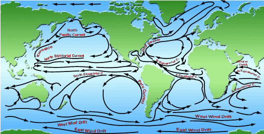 y 3- Currents
Objectives:
.Identify the names of ocean currents
.Understand the purpose of currents
. Recognize the affects of ocean currents on plants, animals, and navigation routes
Vocabulary: Coriolis Effect, convection current, course, current, delta, estuary, equatorial currents, gulf stream, gyres, polar currents, rip currents, trade winds, turbidity currents, upwelling,
Start with a KWL chart on the board. Ask students what they already know about ocean currents. Read: Tracking Trash by Lori Griffin Burns. Discuss the purpose of ocean currents: how plants, animals, and humans use currents. Have students record their predictions in their interactive notebooks. Using Google Earth look show and describe the Gulf Stream, Kuroshiro Current, East Australian Current (EAC), Antarctic Circumpolar, North and South Equitorials and East Greenland. Have students discuss and record the importance of these currents. Following the discussion, students will participate in an activity which tests how salinity, temperature, and wind affect ocean currents. Students will record predictions and observations in their interactive notebooks.
Assessment-Vocabulary crossword worksheet
 Day4- Waves
. Understand how waves move
. Identify different waves
. Create and observe wave movement and wave energy
Vocabulary: rogue wave, storm surge, tsunami,
Start with a KWL chart. Ask students: How do waves move? Read: What Makes a Ocean Wave by Melvin Berger. Provide students information to put into their interactive notebooks. Students will listen to sound clips (soundbible.com) of ocean waves. Following the sound clips and discussion, students will participate in an activity to simulate ocean waves using a pan of water, fan, and marbles to represent wave movement and energy. Have students record their predictions and observations in their interactive notebooks.
Assessment: Motion of the Ocean Quiz
 Day 5- Tides and the Relationship Between the Earth, Moon, and Sun
Objectives:
. Identify tides
. Identify the relationship between the Earth, Moon, and Sun
. Distinguish Neap tide and Spring tide
Vocabulary words: tide, spring tide, neap tide, low tide, high tide, moon, phases and gravitational pull
Ask students: Have you ever been to the beach? When you find your spot to lay out your towels or blankets, have you ever noticed that the ocean seems to get closer and closer as time passes along? And then if you are not paying attention your might find your stuff in the water. What is happening? Have students record their predictions in their interactive notebooks. Show animation: NASA Ocean Tides. Ask students which is low tide and/or high tide. Explain Spring tide and Neap tide. Students will add information sheet into their interactive notebook and highlight the essential information with the teacher. Following the discussion the students will make an Earth, Moon, and Sun relationships foldable.In closing, students will work in groups to complete the Motions of the Ocean worksheet
Assessment- Motions of the Oceans Graphic Organizer Worksheet

Day 6-Climate Changes
Objectives:
. Understand the relationship between the ocean and climate changes
. Identify the causes of climate changes
. Identify the effects of climate change on the ocean
Vocabulary: atmosphere, carbon dioxide, climate, climate change, emissions, fossil fuels,global warming, greenhouse effect, solar radiation, weather
Start with a KWL chart drawn on the board. Ask students: How does the ocean influence the climate? Read Fever in the Ocean by Stephen Aitken. Discuss reasons how the ocean influence the climate temperature. Watch NASA's Climate Kids: Oceans of Climate Change. Provide an information sheet to place in the student's interactive notebook. Discuss the effects of climate change on the ocean and what can be done to restore the damage. Show my digital story video about artificial reefs. In closing, have students to engage in Think-Pair-Share about what they learned about climate changes on the Ocean. Record shared information in their interactive notebooks titled: T-P-S.
Assessment: Global Warming or Climate Change? Worksheet
Day 7-The Ocea
 n Floor
Objectives:
. Identify the landscape features of the ocean floor
. Explain the changes in light, pressure, and temperatures at different depths of the ocean
. Demonstrate knowledge by creating an ocean floor project
Vocabulary: Abyssal zone, Bathyal zone, benthos, challenger deep, coastline, continental edge, continental margin, continental rise, continental shelf, continental slope, East Pacific Rise, Intertidal zone, Mariana trench, Neritic zone, trench,
Review vocabulary words essential to this lesson. Read: Down Down Down by Steve Jenkins.
Discuss how the illustrations in the book reflect the depths of the ocean, specifically light. Using Google Earth, students will experience life on the ocean floor, the zones, and observe the landforms that form the ocean floor. Provide information to place in the student's interactive notebook.Following the discussion, students will create a Life Zones of the Ocean foldable. In closing, the students will engage in a Think-Pair-Share activity and record shared information in their interactive notebooks.
Assessment: Ocean Quiz
 8-Marine Life
Objectives:
. Identify marine plants and animals
. Demonstrate knowledge of marine food web
Vocabulary: aquatic biome, fish larvae, photosynthesis, phytoplankton, predator, zooplankton
Review vocabulary words. Provide information for students to place into their interactive notebooks. Present a PowerPoint/Prezi to engage and inform students about marine plants and animals. Guide the students by highlighting the essential information. Following the discussion Students will make a ocean food web foldable. In closing, students will answer the following questions into their interactive notebooks:
Assessment- What phytoplankton are and where you find them. Draw a picture. What a
 re zooplankton and where do you find them? Draw a picture. Over the next couple of days students will create a classroom mural of life under the sea. Included in the mural students will create the depth zones with the appropriate plants and animals that live within. ( ex. courtesy of Google images: a Seattle school)
 Day 9- Exploring the Ocean
Objectives:
. Describe how we explore the ocean
. Recognize the tools and equipment used to explore the ocean
. Understand why we explore the ocean
Vocabulary: VENUS glossary-words about underwater equipment, tools, and landforms.
Start with a KWL chart. Ask students: How do we know what we know about what lies beneath the ocean water? Have students record their predictions into their interactive notebooks.
Guided by the teacher, the class will embark on a webquest to Explore the Ocean from Under Water to Space. Topics that are addressed include: deep sea conditions that might make it hard to explore the deepest depths of the ocean, how deep can scuba divers, submarines, and other ocean vehicles can dive, using satellites from space can explore the ocean, and compare/contrast underwater and space explorations of the oceans. In closing, have students engage in Think-Pair-Share and record each others information into their interactive notebooks.
Assessment: Write Ten Things About the Ocean worksheet
 Day 10-Human Impact
Objectives:
.Recognize the human impact on the environment
.Examine recent environmental crisis
.Interpret an oil spill and what concerns apply
Vocabulary: crisis, impact, stakeholder, waste, well
Start with a KWL chart drawn on the board. Ask students: What human actions have affected the environment? Read All the Way to the Ocean by Joel Harper. Discuss the various ways humans are harming the ocean. Have students record their predictions in their interactive notebooks. Ask students: are you familiar with the Gulf Oil Spill from May 2010? What do you know about the spill? What are some ways you think the spill could affect the environment around it? Are you familiar with the term stakeholder? What is a stakeholder? Who were some stakeholders in the oil spill crisis?Watch a video and the Louisiana oil spill from 2010. Guide students to highlight essential information in their interactive notebooks.
Activity (p.43): Tell students that today they will be traveling in a time machine back to June 2010 to simulate their response to the Gulf oil spill. They will be divided up into groups and be assigned a specific stakeholder role (scientists, oil company officials, fishing industry and government response team). As a group students will research how their stakeholder would interpret an oil spill and what their main concerns would be.
Each stakeholder will be given the following questions to keep in mind as they research:
- Scientist: What are the major short and long-term concerns regarding the environmental impact of oil spills?
- Oil Company officials: What are some ways to stop the flow of oil leaking out of the well? How will you defend your company to the public?
- Fishing industry: How might the oil spill affect fishing, both presently & in the future? What are some ways the industry has responded in the past?
- Government response team: What are some ways to stop the oil leaking out of the well? Who will you work with to stop the leak?
Students will use classroom computers and books about oil spills to research information. Assessment: Students will present their findings to the class.
In closing, have students answer the following questions in their interactive notebooks:
What are some ways that future oil spills can be prevented?
What can kids do to help the areas affected by the oil spill?
provide students a study guide to review for the unit test the following week.
Foldables
The Life Zones of the Ocean


Land--Intertidal Zone "Littoral zone"--Neritic Zone "Sublittoral zone"--Bathyal Zone "Midnight zone"--Abyssal Zone "Pelagic zone"
includes the plants and animals that live at the associated depths
Tides and the Relationships Between the Earth, Moon, and Sun


Front Back Back
Depicts the relationships between the ocean tides and the Earth, Moon, and Sun
pic #2 Inside- left=Rotation and Revolution, middle=Moon Phases, Right= Tides, Year & Month, and Night & Day
pic#3- illustrations of the associated phases
pic #4-Back= Seasons
Ocean Food Web Foldable


Phytoplankton--Zooplankton--Fish Larvae--Small Fish--Predator "Shark"
Literature Connections
 All the Way to the Ocean by Joel Harper. 2006. p.22. Freedom Three Publishing (978-0971425415). Gr.3-5.
A little book with a very important message. This book conveys how important it is to protect the ocean. It details the impact of sewer waste streaming into the ocean that inevitably harms the marine ecosystem. Everyone, young and old has a vital role in protecting the environment. To reinforce the necessity of recycling, this book is printed using recycled paper and soy ink.
 At the Sea Floor Cafe by Leslie Bulion. Illust. by Leslie Evans.2011. p.48. Peachtree Publishers (978-1561455652). Gr. 3-5.
A funny and creative cross-curricular book that links science and language arts into an engaging collection of poems about the strange and unusual creatures found in the ocean. You will find poems written in all different forms: double dactyl, kyrielle, haiku, cinquain, limerick, triolet, and epigram. The poems are quirky, funny, and full of factual tidbits that please kids, parents, and teachers.
 Down Down Down by Steve Jenkins. 2009. p.40. Houghton Mifflin Books for Children (978-0618966363). Gr. K-5.
Did you know that more people have been to the moon than to the depths of the ocean? Wonderfully illustrated, as you dive deeper and deeper into the book the art and illustrations reflect your voyage. The book presents information starting at sea level and descends accordingly. During your dive you are provided information about the creatures that live at the different depths entered.
 Explore Earth's Five Oceans by Bobbie Kalman. 2010. p. 32. Crabtree Publishing Company (978-0778730910). Gr. 1-3.
A great book that geographically locates the 5 oceans of the world: Atlantic, Pacific, Arctic, Indian, and Southern oceans. Since the oceans cover over 70% of the Earth it is important to understand how they are interconnected and how vital they are to the sustainability of this planet. Included are the physical and ecological characteristics found in and around the oceans.
 Fever in the Ocean by Stephen Aitken. 2011. p. 32. Looking Glass Library (978-1616416720). Gr. 1-5.
Our oceans have a vital role in the sustainability of the environment in which plants, animals, and humans live. The oceans regulate the climate, but as the climate changes the marine life becomes threatened. This book illustrates the effects and affects of climate changes on oceans around the world. Most importantly, children are encouraged to help save the planet.
 I Wonder Why, The Sea is Salty by Anita Ganeri. 2011. p. 32. Kingfisher Publishing (978-0753465523). Gr.K-3.
Children have that endearing desire to ask "why" questions about anything and everything! This book answers their "why" questions about the oceans with colorful illustrations and explanations of ocean shorelines, the depths of the ocean, animals that inhabit the ocean, along with unusual facts you did not know about the ocean.
Tracking Trash:
 Flotsam, Jetsom, and the Science of Ocean Motion by Lori Griffin Burns. 2010. p.64. Sandpiper; Reprint edition (978-0547328607). Gr. 4-12.
Who knew your little yellow rubber ducky could help track ocean currents. Tracking Trash details ocean currents from the data obtained from coursing debris found in and along the ocean and shorelines. Included in the book is an environmental awareness to the harmful effects this debris/trash impacts upon marine life and the environment. You will find at the end of the book a glossary of terms and annotated website resources and books.
 What Can We Do About: Oil Spills and Ocean Pollutants? by David J. Jakubiak. 2011. p. 24. Powerkids Printing (978-1448851126). Gr. 2-5.
Oil spills, pollutants, and industrial, agricultural and residential
waste are affecting our marine ecosystems around the world. In this book, children are encouraged to become environmentalists and take part in reducing toxic waste that is harmful to the environment and encourage others to follow to ensure a sustainable planet for the future.
 What Makes an Ocean Wave? by Melvin Berger. 2001.p.48. Scholastic Reference (978-0439148825). Gr. K-5.
An easy reader packed full of everything you should know about the oceans. This book covers information about the ocean's geography, physical characteristics such as waves and depths, along with the ecological issues that support or threaten it's ability to sustain the planet.
 World Without Fish by Mark Kurlansky. Illust. by Frank Stockton. 2011. 192p. Workman Publishing Company (0761156070). Gr. 5-9.
While the ocean is essential to the sustainability of the planet, it is in a precarious state. The biggest threat to the oceans are humans! This book is written specifically for children to highlight the harmful effects on the oceans, fish, and the environment as a whole. Children and adults will learn what they can do to prevent further harm to Earth's vital resource. This book can be incorporated into a classroom Language Arts lesson and/or Science lesson either read by the student or by the teacher to the class.
Web Resources
ARKive: Explore ARKive's threatened marine species using Google Earth. A fascinating exploration around the world to locate and identify the various endangered marine animals.
BBC: Journey to the Deep
Take a dive into the depths of the ocean where you will discover marine animals, some of which you might have never seen before.
BBC: Open Ocean
As a striped marlin you are a predator of the sea. In order for you to navigate your ocean habitat you have to answer questions. However, if you answer a question wrong, you might end up as a someone else's meal yourself!
EPA: Take a Climate Change Expedition
This interactive adventure takes you on a trip around the world to learn about the changing climate causes and effects. Along the way are videos to watch and challenge questions to answer before advancing to the next location.
Jean- Michel Cousteau Ocean Adventures: Kure Waste Chase
Kure Atoll an ocean island off the coast of Hawaii has been overtaken by senseless trash washing in from the ocean from human negligence. Now it is threatening the lives of animals. Your mission in this game is to pick up as much trash as you can in the time allotted. Good luck!
Click the "information" links in the daily lesson plans for individual topic resource sites
Assessment Resources
Education World: Oceans true or false
Estuary Education: Test your estuarine wisdom
Funschool Kaboose: Under the Sea Quiz
Fun Trivia: Oceans for Kids Trivia Game
Glencoe McGraw-Hill- Ocean Motion Quiz
K-12: Marine Animals Quiz
NASA: Global Climate Change-What is Happening to the Ocean?
National Environmental Education Week: Ocean Bee Quizzes
National Geographic Kids- Quiz You Noodle: Ocean Creatures
Ocean WebQuest Rubric
PBS: The Voyage of the Odyssey-Human Impact questions & answers
Science and Technology: Ocean Region-Ocean Floor Quiz and Answers
Science and technology: Ocean Currents Quiz and Answers
The Simple School: Let's Learn About the Ocean Vocabulary Information and -Worksheets
SolPass: 5.6 Ocean Unit Study Guide with Quiz and Test Questions
Project Resources
Under the Sea WebQuest-2 weeks
Ocean Floor Project- 5th Grade